Travel time map
Smappen is a map that tells you where you can travel to in a given amount of time or by covering a certain distance.

How far?
Depending on the mode of transport you pick, smappen looks at lots of criteria (speed limit on each type of road (city, countryside, highway, etc.), and draws the area that you can reach when travelling the specified distance or time.
These travel-time areas are also called isochrones or catchment areas.
Based on travel times
By car
By bicycle
On foot
A driving-radius map tool
Use smappen to get the right answers.

To choose the best location for your business
smappen provides you with population data on your areas, so that you know which is the best location for your business.
To optimize your logistics (delivery, pricing, technicians, etc.)
Save time and money by providing the best-optimized areas for your deliveries or technicians.
To go and visit friends
Just moved to a new city? Friends all over the country? Find where you can get to in a given travel time.
To target your marketing campaigns
Easily extract zip codes from your areas, for the best-targeted campaigns.
To find your next home or job
Want to move, but don’t want to be too far away from your place of work? smappen shows you the ideal geographic area where you should house-hunt, with a variety of home-to-workplace travel times.
The complete guide about travel time maps
Travel time is an essential element that shapes our daily lives, influencing decisions ranging from our commutes to work, to healthcare accessibility, leisure activities, and urban planning. The ability to understand, calculate, and visualize travel time is a game-changer in modern navigation and decision-making.
Behind the scenes of this crucial concept lies technology and data, working together to create what we call “travel time maps.” These maps are not just colorful representations but tools that empower us to make informed choices about where we go, how we get there, and how long it will take.
In this comprehensive guide, we will embark on a journey to explore the significance of travel time and travel time maps in our fast-paced world. We will delve into the technology that underpins their creation and see how data makes travel time mapping possible. Throughout this exploration, we’ll discover the practical applications of travel time maps and discuss strategies to optimize travel time for a more efficient and enjoyable life. So, let’s navigate the world of travel time and its mapping, enhancing the way we experience the world around us.
Understanding travel time
Travel time is more than just a measure of how long it takes to get from point A to point B. It’s a fundamental concept that profoundly affects our daily routines and decisions. In this section, we will unravel the core concept of travel time and its multifaceted impact on our lives.
At its heart, travel time encapsulates the minutes, hours, and sometimes even seconds that stand between us and our destinations. It governs our commutes to work, school runs, and even the time it takes to enjoy a day out with friends. Understanding travel time is the key to unlocking a more efficient and enjoyable life.
As we delve deeper, we will explore the multitude of factors that influence travel time. Weather, with its unpredictable whims, can either expedite or delay our journeys. Traffic congestion in urban jungles can turn a quick trip into a frustrating ordeal, while our choice of transportation mode can be the difference between a leisurely stroll and a hectic rush.
But what ties all these factors together into a coherent and user-friendly concept? The answer lies in the world of “travel time maps.” These visual representations take complex data on weather, traffic, and transportation modes, and present it in a way that’s easy to comprehend. In the next section, we will unravel the technology and data that make the creation of these maps possible.
Creating travel time maps
Travel time maps are the result of meticulous data integration and advanced GIS technology. These maps require access to a wide array of data sources, including real-time traffic information, location data, and comprehensive transportation networks. This data forms the foundation upon which travel time maps are built.
One of the pivotal elements in this process is GIS technology, such as the one offered by Smappen. Smappen, as an innovative geomarketing solution, plays a significant role in creating travel time maps. It leverages GIS technology to process vast datasets and produce visually intuitive maps that help individuals and businesses make informed decisions.
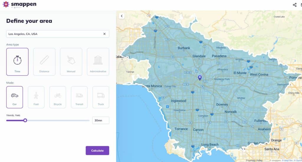
Creating a travel time map with Smappen can provide valuable insights for location-based decision-making. Below is a step-by-step tutorial on how to create a travel time map for free using Smappen:
- Go to smappen.com/app/
- Open the area creation panel on the top left
- Write your starting address
- Select the time
- Choose the means of transport
- Click on “Compute” button
Your first travel time area is created! For more detailed instructions, you can follow our tutorials.
Interpreting travel time maps
Understanding how to read and interpret a travel time map is vital in unlocking the wealth of information it offers to individuals, businesses, and decision-makers alike. These maps are designed to provide valuable insights into travel time, allowing for informed choices. Here, we’ll delve into the key aspects of interpreting travel time maps while incorporating relevant SEO keywords.
Color-Coding and Legends: A fundamental element of any travel time map is the color-coding scheme, where different areas are shaded in various colors to represent varying travel times. The intuitive use of colors serves as a visual guide, with darker hues typically signifying longer travel times and lighter shades indicating shorter journeys. Understanding these color patterns is crucial for quick and accurate interpretation of the map, especially when time is of the essence. Additionally, legends are often provided to clarify the specific time intervals associated with different colors, making it easier to gauge travel durations.
Real-World Examples and Decision-Making: The true power of travel time maps becomes evident when we witness them in action in real-world scenarios. These maps are not just abstract data representations; they play a practical role in guiding decisions. For instance, consider a business owner looking to determine the ideal location for a new store. By consulting a travel time map, they can pinpoint areas with shorter travel times to their target demographic, leading to better strategic choices. Similarly, urban planners utilize travel time maps to identify areas with limited transportation accessibility, paving the way for more efficient infrastructure development. These practical examples showcase the indispensable role travel time maps play in enhancing decision-making processes.
User-Friendly Digital Platforms: In the digital age, travel time maps have become more accessible and user-friendly than ever. Many platforms, such as Smappen, offer intuitive interfaces that make map interpretation a breeze. These digital tools allow users to zoom in, pan, and interact with the map, exploring different regions effortlessly. Whether you’re planning your daily commute or seeking the ideal location for a business expansion, the user-friendly nature of digital travel time maps streamlines the process. With a few clicks, you can gain valuable insights into travel times, empowering you to make more informed decisions in an ever-changing world.
By grasping the principles of color-coding, legends, and practical applications, you’ll be well-prepared to harness the potential of travel time maps in your daily life or business endeavors. Understanding how to interpret these maps effectively opens the door to better planning, improved decision-making, and optimized efficiency.
Applications and importance
Broad Applications Across Sectors: Travel time maps find relevance in a plethora of sectors, serving as a fundamental resource for informed decision-making. In the realm of transportation, they aid in optimizing routes and schedules for public transit systems, reducing commuter travel time and enhancing the overall transit experience. In healthcare, travel time maps guide medical facilities in identifying areas with limited accessibility, ensuring that critical services are within reach for all members of the community. Furthermore, urban planners employ travel time maps to develop efficient infrastructure and to design cities that are more accessible to all. These maps, enriched with data, play a pivotal role in enhancing the quality of life for residents and commuters alike.
Leveraging Travel Time Maps for Decision-Making: Businesses and individuals stand to gain significant advantages by leveraging travel time maps in their decision-making processes. For businesses, the strategic location of a store, warehouse, or distribution center can be a game-changer in terms of customer reach and operational efficiency. Travel time maps provide valuable insights into the ideal location for maximum accessibility. Individual commuters and travelers, too, can benefit from these maps by planning their daily journeys more efficiently, avoiding congestion, and optimizing their schedules.
Optimizing Efficiency and Accessibility: The value of travel time maps lies in their ability to optimize efficiency and accessibility in everyday life. For businesses, this means maximizing the reach of their services while minimizing operational costs. For individuals, it translates to reduced stress, more time for leisure and productivity, and a higher quality of life. With these maps in hand, individuals can make choices that take into account the time it takes to reach their destinations, ultimately improving the balance between their personal and professional lives.
Optimizing travel time with maps
Efficiently managing your travel time is not just about reaching your destination; it’s about transforming your daily journeys into smoother and more productive experiences. In this section, we will share practical strategies and tips for using travel time maps to your advantage, all while incorporating relevant SEO keywords for enhanced visibility.
Practical Strategies for Efficiency:
Plan Ahead: The cornerstone of optimizing your travel time begins with planning. Use travel time maps to foresee potential bottlenecks, traffic congestion, or delays in your route. By being proactive and considering these factors, you can plan your trips at times that minimize disruptions.
Combine Trips: If you have multiple errands or destinations, strategically combine them to minimize travel time. Travel time maps can help you identify areas where you can complete multiple tasks within a single journey, optimizing your schedule and reducing the overall time spent traveling.