Drive Time analysis
Drive Time Map
>> Get demographics report by a chosen radius
>> Search points of interest
>> Import your data to organize your territories
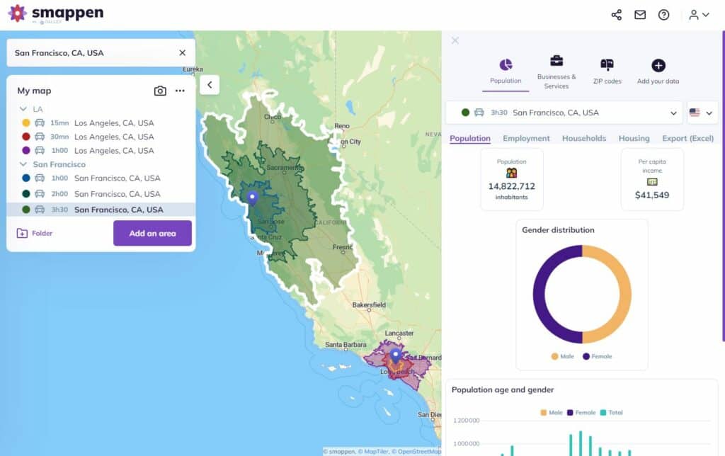
Demographics report

Smappen gives you the exact indicators for each of your areas from the Census database. Start analyze your areas to find the best location
Points of interest
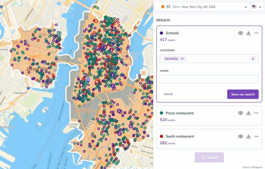
Search within 250 millions of references to spot your competitor, schools, stations and transports and understand the economic tissue
Data import
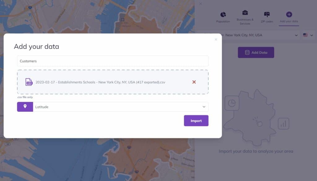
Go further with your analysis and import your own data (CRM, …) to understand your customers’ behavior

I have been searching for this software for years! smappen is nothing short of incredible. It is exactly what I needed and produces fantastic results. And the user interface… It is so simple!
I manage 25 territories across the US for medical device sales distribution. Mapping territories for my reps has never been easier. smappen turned me into a hero at the company!

Exceptional and personal training and support. It did exactly what I wanted it to do, with a very high degree of accuracy.
In today’s dynamic business landscape, understanding “drive time maps” is a critical skill for organizations seeking to optimize their operations. This blog post will provide an in-depth exploration of drive time maps, their significance, and how they can be used effectively.
What are drive time maps?
The drive-time analysis uses isochrones to create drive-time areas to get demographics inside this zone. It permits the analysis and assessment of the market potential of a territory. Geographic analyses are used by franchisors, retailers, and sales and marketing persons who need to organize their prospection, optimize their campaigns or, attribute sales territories.
The significance of drive time maps in geomarketing and business strategy
In the realm of geomarketing and business strategy, the significance of drive time maps cannot be overstated. These maps, often generated with the assistance of sophisticated geospatial tools like Smappen, offer invaluable location-based insights that empower businesses to make informed, data-driven decisions.
Location-based decision making:
Drive time maps are instrumental in location-based decision making. They enable businesses to choose the most strategically advantageous sites for their operations, stores, or service centers. By visualizing areas reachable within a defined travel time, organizations can pinpoint optimal locations that maximize accessibility to their target customer base.
Enhancing customer reach and convenience:
Understanding drive time maps is pivotal for organizations looking to enhance customer reach and convenience. By ensuring that their locations are easily accessible within specific travel time parameters, businesses can elevate customer convenience. This can result in increased foot traffic, higher service utilization, and improved customer satisfaction.
Empowering market analysis:
Drive time maps are a fundamental tool for market analysis. They provide businesses with the ability to assess the potential of specific geographic areas and identify gaps in their market reach. This, in turn, informs data-driven decision making and market expansion strategies, ultimately contributing to a competitive edge in the business landscape.
Creating drive time maps
-
Modes of Transportation
Drive time maps can be generated for various modes of transportation, including car, walking, biking, and public transportation.
-
Geospatial Software
Professional geospatial tools can be used to create accurate and detailed drive time maps.
Well, so how do I create a drive time map?
Creating a drive time map, including using a tool like Smappen, involves a series of steps to help you visualize the areas reachable within a specified travel time. Here’s a general guide on how to create a drive time map:
1. Choose a Location:
Start by selecting a central location on the map where you want to measure drive times from. This could be the location of an existing store, a potential retail site, or any point of interest.
2. Define Travel Parameters:
Determine the mode of transportation you want to analyze, such as driving, walking, biking, or public transportation. You’ll also need to specify the maximum travel time or distance you want to consider, for example, a 15-minute drive time.
3. Use Geospatial Software:
Geospatial software, like Smappen, can greatly simplify the process. Here’s how you can do it using Smappen:
a. Log in to your Smappen account. b. Click on the “Create Catchment Area” or similar option.
4. Set Up Your Analysis:
a. Select the central point by inputting its address or coordinates. b. Choose your preferred mode of transportation (e.g., “car” for driving). c. Specify the maximum travel time (e.g., 15 minutes).
5. Generate the Drive Time Map:
Click on the “Generate” or “Create” button. The software will process the data and create the drive time map.
6. Analyze the Results:
Once the drive time map is generated, you can view it on the map interface. The map will show shaded areas that represent where you can reach within the specified travel time. Darker areas indicate shorter travel times, while lighter areas represent longer travel times.
7. Save and Export Data:
Smappen and similar tools often allow you to save and export the data. You can save the map for reference or further analysis, and in some cases, you can also download the data in formats like Excel.
8. Interpret the Map:
Analyze the drive time map to make informed decisions. For instance, you can identify suitable locations for a new store based on the accessibility to your target audience or optimize delivery routes.
9. Refine and Iterate:
You can refine your analysis by adjusting the parameters, such as changing the travel time or trying different modes of transportation. This iterative process helps you find the most suitable locations and make data-driven decisions.
Creating drive time maps with Smappen or similar tools streamlines the process and provides accurate, up-to-date geospatial information for your business. These maps are invaluable for location-based decision-making, market analysis, and customer reach optimization.
Practical applications of drive time maps
Drive time maps have a diverse range of practical applications in geomarketing and location-based analysis. These applications are instrumental in aiding businesses and organizations in optimizing their strategies and decision-making processes.
Retail store location selection:
In the retail industry, the ability to select optimal store locations is paramount. A drive time map is an essential tool for retailers to identify prime locations that are easily accessible to their target customers. By visualizing the areas reachable within specific drive time constraints, retailers can strategically position their stores for maximum customer reach and foot traffic.
Service delivery planning:
For businesses offering services or deliveries, drive time maps play a crucial role in service delivery planning. By analyzing these maps, organizations can optimize their delivery routes and schedules. This leads to more efficient operations, ensuring that services are delivered promptly and cost-effectively, resulting in improved customer satisfaction.
Market expansion strategy:
Drive time maps are indispensable for organizations seeking to expand into new markets. By evaluating these maps, businesses can identify promising areas with untapped potential. This empowers them to formulate data-driven market expansion strategies, allowing for calculated and informed decisions in pursuing new opportunities.
Healthcare accessibility:
Healthcare providers can utilize drive time maps to assess accessibility to their facilities. This helps in ensuring that patients have convenient access to medical services. By analyzing these maps, healthcare organizations can identify underserved areas and plan new clinic locations or services to better cater to the healthcare needs of the community.
Real estate investment analysis:
In the real estate industry, drive time maps assist in evaluating property values and investment potential. Prospective real estate investors can use these maps to understand the convenience and accessibility of a location, ultimately aiding in making informed decisions about property purchases and investments.
Challenges and considerations in drive time map analysis
While drive time maps are powerful tools for location-based analysis and decision-making, there are several challenges and considerations that businesses should bear in mind when using them:
1. Data Accuracy and Quality:
One of the primary challenges in drive time map analysis is ensuring the accuracy and quality of the geospatial data used. Inaccurate or outdated data can lead to misleading results, potentially impacting decision-making. It’s crucial to source data from reliable providers and regularly update it to maintain the precision of drive time maps.
2. Real-Time Traffic Variations:
Drive time maps are highly dependent on the current traffic conditions, and these conditions can change throughout the day. Businesses should consider real-time traffic variations when analyzing drive time maps, as traffic congestion can significantly affect travel times. Integrating real-time traffic data into the analysis can provide a more realistic picture of accessibility.
3. Mode of Transportation:
Selecting the appropriate mode of transportation is a consideration in drive time map analysis. Different businesses may require maps for various transportation options, such as driving, walking, or biking. It’s essential to choose the mode that aligns with the specific needs of the analysis, as travel times can vary significantly between modes.
4. Large Geographic Areas:
For businesses operating in large geographic areas, creating drive time maps can be resource-intensive. Analyzing extensive regions may require additional computing power and longer processing times. It’s essential to allocate sufficient resources for generating comprehensive drive time maps in such cases.
5. Complex Geographies:
In areas with complex geographies, such as mountainous terrain or water bodies, drive time maps may present unique challenges. Geographical obstacles can impact travel times and accessibility. Special attention should be given to these areas to ensure accurate and relevant mapping.
6. Regular Data Updates:
To maintain the reliability of drive time maps, it’s crucial to regularly update the underlying data. This includes factors like road networks, traffic information, and geographic boundaries. Keeping data up to date ensures that drive time maps accurately reflect real-world conditions.
Start using smappen now